

A 4.6-mile, east-west pedestrian and bicycle path known as the Ellicott Trail is at the halfway point to completion, according to the coordinator of the $1.7-million venture that will traverse through roads, parks, wetlands and abandoned railway beds in the Town and City of Batavia.
Speaking at a public information meeting on Tuesday night at the City Centre Council Chambers, Thomas Lichtenthal Jr., Town of Batavia highway superintendent and assistant engineer, said the project is on schedule.
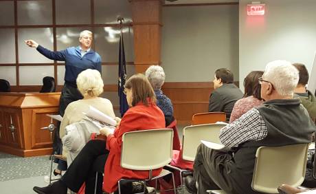
“We hope to be on the path (pun intended) by late summer or early fall of next year,” Lichtenthal (in photo at top) said to about two dozen people in attendance. “And we’d like to see it finished before Christmas, hopefully by Thanksgiving.”
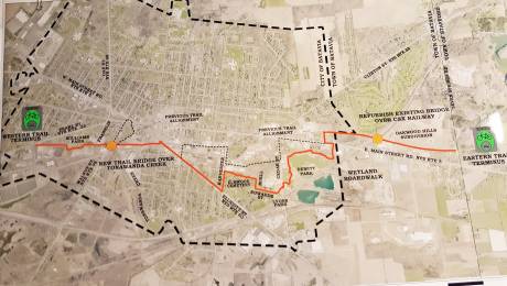
Lichtenthal’s presentation took the audience from one end of the trail to the other, pointing out specific tasks that need to be done at various points. The trail’s eastern entrance will be on Seven Springs Road, near the new Oakwood Hills subdivision, and its western entrance will be on Pearl Street Road, in the vicinity of River Street.
In between, it will pass over a refurbished existing bridge over the CSX railway off of East Main Street Road, wind its way through DeWitt Park off Cedar Street (where a “boardwalk” will move bikers and walkers over wetlands there), move on to Lions Park and Elmwood Cemetery, travel down Ellicott Street Road, behind the proposed Ellicott Station development, across a new trail bridge on Walnut Street over the Tonawanda Creek, and past Williams Park to Pearl Street Road.
But before all that can happen, construction crews have much dirt to move and concrete to pour as plans include the construction of a 10-foot wide stone dust trail on the off-road sections and a 10-foot wide sidewalk on the road sections.
Furthermore, right-of-way agreements (easements) with owners of about 16 private properties that are affected by the trail need to be signed, Lichtenthal noted.
“We are talking to property owners, and letting them know what needs to be done,” he said. “All right-of-way owners (and several of them were at the meeting) are on board with the project at this point.”
The Town of Batavia is acting as lead agency for the project, which is being funded for the most part – 80 percent -- by a New York State Department of Transportation grant. The Town of Batavia and City of Batavia are contributing 10 percent each.
A Municipal Facility Grant of $250,000 acquired through the efforts of Sen. Michael Ranzenhofer will pay for the new bridge on Walnut Street, Lichtenthal said, while a portion of funds from a Genesee County Parks Department capital project will pay for the boardwalk at DeWitt Park.
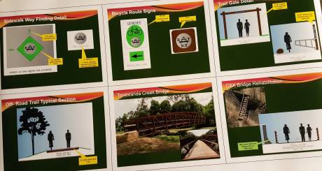
Lichtenthal said the trail will be populated by sidewalk way-finding signs and bicycle route signs, and will be open only during daylight hours – dawn to dusk.
He said providing clear directions and making sure those who use the trail are safe are priorities. He and Matthew Worth, director of public works for the City of Batavia, are working together on the signage details.
“With the on-road segments, the big thing with that is going to be way-finding – to let the people know that if you’re on the trail, you’re on the trail, and to be able to follow that trail all the way through the city so that you don’t get lost as you’re making your way from one end to the other,” he said.
City Councilwoman Rose Mary Christian said she was in favor of the project but was concerned about the safety of pedestrians and bikers, especially those who may be in need of help.
Lichtenthal and Worth responded by stating that fire, medical and police vehicles will be able to drive on the trail – except over the Walnut Street bridge – and that city police will employ their bicycle patrols during the spring and summer months. Otherwise, no motor vehicles will be allowed on the trail.
An Edward Street resident said parking and traffic in his neighborhood when Batavia Youth Football League games are being played at Lions Park would make it tough on those using the trail. Worth said city and football officials are talking about relocating the games to a “more suitable” location.
The trail’s main purpose, in Lichtenthal’s view, is to provide an alternative mode of transportation for those wanting to go shopping or enjoy time at city parks.
“Or you can use this as a physical exercise trail … you’ve got 4.6 miles,” he said. “If you go from one end to the other, you’ve got nine miles available for walking and physical fitness.”
He said the primary challenges deal with the off-road sections.
“They’re old, abandoned railroads that haven’t been maintained (and) there’s a lot of tree growth, culverts; there’s all kinds of stuff on those off-road sections that we need to improve those to make this … an off-road experience that’s pleasurable,” he noted.
For Jacob Bodway, a city resident affiliated with the WNY Mountain Biking Association, the Ellicott Trail project is a key tool in attracting Millennials to Batavia.
“If you want to draw young professionals to a community, this is a way to do it,” he said, adding that future plans to extend the trail to Le Roy and also further west will result in people from outside the area coming to use it.
With two of eight milestones on the project timetable in the books (stakeholder meeting and public meeting), the next steps are the submission of the trail’s reevaluation statement by Dec. 9 and advanced detail plans by Jan. 6. Final plans are scheduled to be submitted by February and right-of-way acquisitions completed by March. Bidding on construction is set to take place in April, with work starting in June.

Looking forward to it.
Looking forward to it.
I understand this multi
I understand this multi purpose trail is not for all but for one a long time coming. I can't wait to be one of the first to ride it.. All I can add is that I've been on hundreds of these trails throughout the USA and to use an old Adage, if you build it they will come from home and surrounds.. This is exactly what we need and long overdue....
Just wondering, Mike.
Just wondering, Mike.
Aren't "dawn to dusk" the daylight hours (as opposed to dusk to dawn)?
Also, was there an mention on how the trail will be "closed" during off-hours? Or, what (possible) penalties/fines might be given to those who are traveling on it when it is "closed"?
Is there a website for this
Is there a website for this project, or a link to a higher resolution image of the map?
I hope people will be able to
I hope people will be able to walk their dogs on the trail. (ED: Fixed -- dawn to dusk.)
Ed, if it is to be closed
Ed, if it is to be closed during dusk to dawn, then the penalties, if any, should be the same as for being in the parks after hours.
Sorry about the dusk to dawn
Sorry about the dusk to dawn typo; misread my notes -- Tom Lichtenthal said that residents' "eyes on the trail" will help promote safety and enforcement of the rules -- He also mentioned that trail information will be posted on the Town of Batavia and City of Batavia websites.
Thanks, Billie, John and Mike
Thanks, Billie, John and Mike!
$1.7 Million... yep, just
$1.7 Million... yep, just more taxpayer money frittered away down the black-hole of government spending on non-essential BS. Used by, and benefits a very small segment of our community, yet paid for by money stolen from all.
BTW, what ever happen to this
BTW, what ever happen to this money???
BATAVIA TO RECEIVE $750K FOR BIKE PATH IN CITY - The Batavian October 27, 2014
http://www.thebatavian.com/howard-owens/batavia-receive-750k-bike-path-…